Product Introduction
To achieve better interaction between LBS services and LLM, Amap's MCP Server now covers 12 core service interfaces, providing comprehensive map services for all scenarios, including geocoding, reverse geocoding, IP location, weather queries, cycling route planning, walking route planning, driving route planning, public transport route planning, distance measurement, keyword search, nearby search, and detail search.
To further enhance developer access efficiency and experience, Amap Open Platform provides developers with a general-level SSE protocol MCP service solution.
Product Architecture Diagram
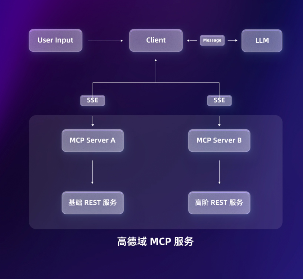
What is SSE?
Server-Sent Events (SSE) is a technology based on the HTTP protocol that allows servers to push data to clients in a unidirectional and real-time manner. In the SSE mode, developers can establish a persistent connection with the server by creating an EventSource object on the client-side. The server then continuously sends data streams through this connection without the client needing to repeatedly send requests.
Product Features
-
Easy to Use: Suitable for regular users based on MCP (SSE) mode, no need to deploy local services, and can be used simply by configuring a URL address.
-
Automatic Upgrades: We will continue to iterate and update without any additional operation needed from users.
-
Easier for LLM Understanding: We have semantically converted the original JSON results, making it easier for LLM to understand the content.
-
Zero Maintenance Cost: Adopts a fully managed cloud service architecture, so users do not need to worry about server maintenance, resource expansion, and other underlying operational issues.
-
Protocol Compatibility: Supports SSE long connections to meet the technical needs of different business scenarios.
Visit the Quick Access documentation to learn how to access the MCP Server SSE service.
Capability Introduction
Geocoding
Convert detailed structured addresses into latitude and longitude coordinates.
Input | address (location information), city (city information, optional) |
Output | location (latitude and longitude) |
Reverse Geocoding
Convert Amap latitude and longitude coordinates into administrative district address information.
Input | location (latitude and longitude) |
Output | addressComponent (location information, including province, city, district, etc.) |
IP Location
IP location determines the location of an IP based on the user-provided IP address.
Input | IP |
Output | province (province), city (city), adcode (city code) |
Weather Query
Query the weather of a specified city based on the city name or standard adcode.
Input | city (city name or city adcode) |
Output | forecasts (weather forecasts) |
Cycling Route Planning
Used for planning cycling commuting routes, considering overpasses, one-way streets, road closures, etc. Supports cycling route planning up to 500km.
Input | origin (start latitude and longitude), destination (end latitude and longitude) |
Output | distance (planned distance), duration (planned time), steps (planned step information) |
Walking Route Planning
Plan walking commuting routes within 100km based on the input starting and ending latitude and longitude coordinates and return the data of the commuting plan.
Input | origin (start latitude and longitude), destination (end latitude and longitude) |
Output | origin (start information), destination (end information), paths (planned specific information) |
Driving Route Planning
Plan commuting travel solutions for small cars and sedans based on the user's start and end latitude and longitude coordinates and return the commuting plan data.
Input | origin (start latitude and longitude), destination (end latitude and longitude) |
Output | origin (start information), destination (end information), paths (planned specific information) |
Public Transport Route Planning
Plan commuting solutions that integrate various public transport modes (train, bus, subway) based on the user's start and end latitude and longitude coordinates and return the commuting plan data. For cross-city scenarios, the start city and end city must be provided.
Input | origin (start latitude and longitude), destination (end latitude and longitude), city (start city), cityd (end city) |
Output | origin (start information), destination (end information), distance (planned distance), transits (planned specific information) |
Distance Measurement
Measure the distance between two latitude and longitude coordinates.
Input | origin (start latitude and longitude), destination (end latitude and longitude) |
Output | origin_id (start information), dest_id (end information), distance (planned distance), duration (time) |
Keyword Search
Search for related POI location information based on user-provided keywords.
Input | keywords (search keywords), city (query city, optional) |
Output | suggestion (search suggestion), pois (location information list) |
Nearby Search
Search for POI location information within a radius based on user-provided keywords and location coordinates.
Input | keywords (search keywords), location (central latitude and longitude), radius (search radius, optional) |
Output | pois (location information list) |
Detail Search
Query detailed information of POI ID obtained from keyword search or nearby search.
Input | id (POI ID obtained from keyword search or nearby search) |
Output | Location detail information location (latitude and longitude), address, business_area (business district), city, type (location type), etc. |
[
  {
    "description": "将一个高德经纬度坐标转换为行政区划地址信息",
    "inputSchema": {
      "properties": {
        "location": {
          "description": "经纬度",
          "type": "string"
        }
      },
      "required": [
        "location"
      ],
      "type": "object"
    },
    "name": "maps_regeocode"
  },
  {
    "description": "将详细的结构化地址转换为经纬度坐标。支持对地标性名胜景区、建筑物名称解析为经纬度坐标",
    "inputSchema": {
      "properties": {
        "address": {
          "description": "待解析的结构化地址信息",
          "type": "string"
        },
        "city": {
          "description": "指定查询的城市",
          "type": "string"
        }
      },
      "required": [
        "address"
      ],
      "type": "object"
    },
    "name": "maps_geo"
  },
  {
    "description": "IP 定位根据用户输入的 IP 地址,定位 IP 的所在位置",
    "inputSchema": {
      "properties": {
        "ip": {
          "description": "IP地址",
          "type": "string"
        }
      },
      "required": [
        "ip"
      ],
      "type": "object"
    },
    "name": "maps_ip_location"
  },
  {
    "description": "根据城市名称或者标准adcode查询指定城市的天气",
    "inputSchema": {
      "properties": {
        "city": {
          "description": "城市名称或者adcode",
          "type": "string"
        }
      },
      "required": [
        "city"
      ],
      "type": "object"
    },
    "name": "maps_weather"
  },
  {
    "description": "查询关键词搜或者周边搜获取到的POI ID的详细信息",
    "inputSchema": {
      "properties": {
        "id": {
          "description": "关键词搜或者周边搜获取到的POI ID",
          "type": "string"
        }
      },
      "required": [
        "id"
      ],
      "type": "object"
    },
    "name": "maps_search_detail"
  },
  {
    "description": "骑行路径规划用于规划骑行通勤方案,规划时会考虑天桥、单行线、封路等情况。最大支持 500km 的骑行路线规划",
    "inputSchema": {
      "properties": {
        "destination": {
          "description": "目的地经纬度,坐标格式为:经度,纬度",
          "type": "string"
        },
        "origin": {
          "description": "出发点经纬度,坐标格式为:经度,纬度",
          "type": "string"
        }
      },
      "required": [
        "origin",
        "destination"
      ],
      "type": "object"
    },
    "name": "maps_bicycling"
  },
  {
    "description": "步行路径规划 API 可以根据输入起点终点经纬度坐标规划100km 以内的步行通勤方案,并且返回通勤方案的数据",
    "inputSchema": {
      "properties": {
        "destination": {
          "description": "目的地经度,纬度,坐标格式为:经度,纬度",
          "type": "string"
        },
        "origin": {
          "description": "出发点经度,纬度,坐标格式为:经度,纬度",
          "type": "string"
        }
      },
      "required": [
        "origin",
        "destination"
      ],
      "type": "object"
    },
    "name": "maps_direction_walking"
  },
  {
    "description": "驾车路径规划 API 可以根据用户起终点经纬度坐标规划以小客车、轿车通勤出行的方案,并且返回通勤方案的数据。",
    "inputSchema": {
      "properties": {
        "destination": {
          "description": "目的地经度,纬度,坐标格式为:经度,纬度",
          "type": "string"
        },
        "origin": {
          "description": "出发点经度,纬度,坐标格式为:经度,纬度",
          "type": "string"
        }
      },
      "required": [
        "origin",
        "destination"
      ],
      "type": "object"
    },
    "name": "maps_direction_driving"
  },
  {
    "description": "公交路径规划 API 可以根据用户起终点经纬度坐标规划综合各类公共(火车、公交、地铁)交通方式的通勤方案,并且返回通勤方案的数据,跨城场景下必须传起点城市与终点城市",
    "inputSchema": {
      "properties": {
        "city": {
          "description": "公共交通规划起点城市",
          "type": "string"
        },
        "cityd": {
          "description": "公共交通规划终点城市",
          "type": "string"
        },
        "destination": {
          "description": "目的地经度,纬度,坐标格式为:经度,纬度",
          "type": "string"
        },
        "origin": {
          "description": "出发点经度,纬度,坐标格式为:经度,纬度",
          "type": "string"
        }
      },
      "required": [
        "origin",
        "destination",
        "city",
        "cityd"
      ],
      "type": "object"
    },
    "name": "maps_direction_transit_integrated"
  },
  {
    "description": "距离测量 API 可以测量两个经纬度坐标之间的距离,支持驾车、步行以及球面距离测量",
    "inputSchema": {
      "properties": {
        "destination": {
          "description": "终点经度,纬度,坐标格式为:经度,纬度",
          "type": "string"
        },
        "origins": {
          "description": "起点经度,纬度,可以传多个坐标,使用竖线隔离,比如120,30|120,31,坐标格式为:经度,纬度",
          "type": "string"
        },
        "type": {
          "description": "距离测量类型,1代表驾车距离测量,0代表直线距离测量,3步行距离测量",
          "type": "string"
        }
      },
      "required": [
        "origins",
        "destination"
      ],
      "type": "object"
    },
    "name": "maps_distance"
  },
  {
    "description": "关键词搜,根据用户传入关键词,搜索出相关的POI",
    "inputSchema": {
      "properties": {
        "city": {
          "description": "查询城市",
          "type": "string"
        },
        "keywords": {
          "description": "搜索关键词",
          "type": "string"
        },
        "types": {
          "description": "POI类型,比如加油站",
          "type": "string"
        }
      },
      "required": [
        "keywords"
      ],
      "type": "object"
    },
    "name": "maps_text_search"
  },
  {
    "description": "周边搜,根据用户传入关键词以及坐标location,搜索出radius半径范围的POI",
    "inputSchema": {
      "properties": {
        "keywords": {
          "description": "搜索关键词",
          "type": "string"
        },
        "location": {
          "description": "中心点经度纬度",
          "type": "string"
        },
        "radius": {
          "description": "搜索半径",
          "type": "string"
        }
      },
      "required": [
        "location"
      ],
      "type": "object"
    },
    "name": "maps_around_search"
  }
]